Lay of the Land
For those who don't know Puerto Vallarta or the region all that well, here's a Google Earth tour for some insight and perspectives.
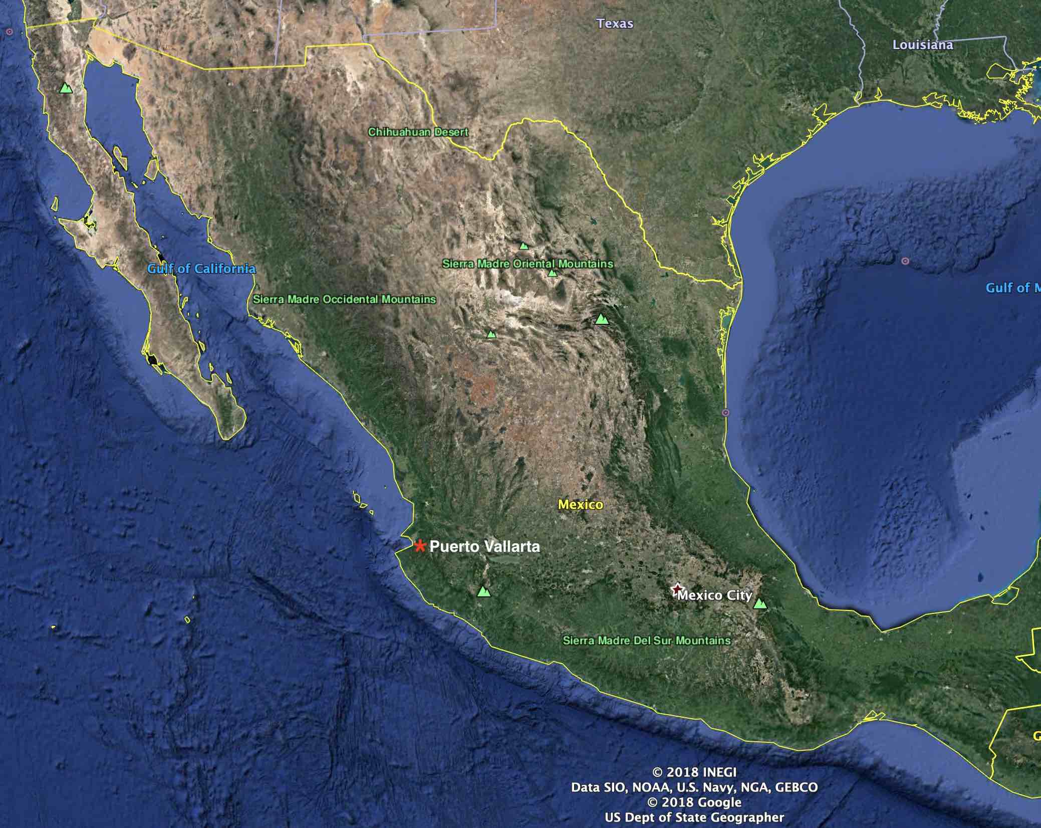
Puerto Vallarta, or its more familiar "Vallarta", PV or PVR, is a city of 250,000 located halfway up Mexico's Pacific coast, deep inside Banderas Bay in the western state of Jalisco.
Looking at a map of Mexico, Puerto Vallarta's location can be quickly determined by the nook found halfway up the Pacific coastline. That nook is Bahia de Banderas and some 30 miles inside the bay exists this coastal city which sprang from the banks of the Rio Cuale.
It's said Puerto Vallarta never experiences hurricanes. That's true from a head-on perspective by way the city is protectlvely situated deep inside the bay. While it's safeguarded from the summer hurricanes that move up the Mexican coast, Hurricane Kenna in 2005, a category 5 storm, reminded us regardless of the bay's protective nature, sea surge can still occur and cause damage. Fortunately, that's proven to be a rare event.
Hurricanes form in the warm tropical waters of southern Mexico each summer and most eventually flow northwesterly towards Hawaii. Some will follow more closely the Mexican coastline before turning west while occasionally a few will continue straight north toward Cabo San Lucas, located at the tip of Baja California.
Most rare are those huricanes that veer east and hit landfall somewhere north of Puerto Vallarta. Kenna came ashore in the area of San Blas, Nayarit, about 100 miles north of PV. Those that do head east inevitably and quickly break apart in their attempt to cross over the Sierra Madres, the mountain chain that runs the length of the country, affectionately known as the Hurricane Buster.
With over 60 miles of coastline and pristine beaches, Banderas Bay is particularly special in a number of ways.
The bay is exceptionally deep in places providing natural shelter to many species of fish and animals who live in the ocean. The bay is a natural habitat for dolphins which can be seen throughout the year. To keep themselves safe, the dolphins patrol the bay to keep sharks out. Consequently, the bay is popular to gray and humpback whales migrating south in the winter months, to safely breed and have their offspring. Whale watching tours from November through March is a popular tourist attraction in Puerto Vallarta. In addition to dolfins and whales, the bay's sealife includes turtles, manta rays, octopus and thousands of species of tropical fish.
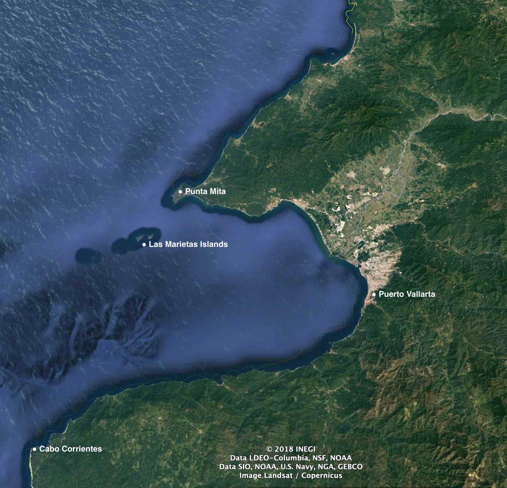
At the bay's mouth are the Las Marietas, a small group of islands that is a national park which is a sanctuary to a few thousand birds, including such species as the blue-footed booby and the red-billed tropicbird. The islands are recognized as a UNESCO ecologically protected site.
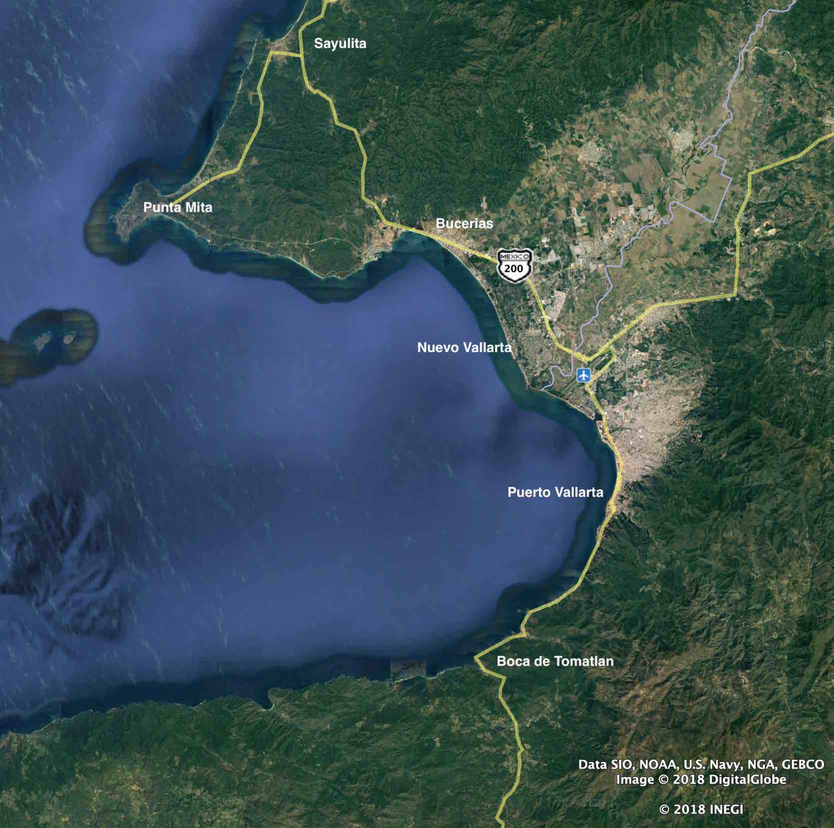
Looking at the accompanying image, you see the bay fronts a large valley wedged between two ranges of the Sierra Madre mountains. Through this fertile valley flows the Ameca River. Farmers and ranchers here grow watermelon and mangos among other crops.
Following the route of the Ameca River, the purplish squiggly line running through the middle of the valley in the accompanying image, serves as the border separating the states of Jalisco and Nayarit. Next to where the Ameca flows into the bay is Puerto Vallarta's international airport (Licenciado Gustavo Díaz Ordaz [Code: PVR]).
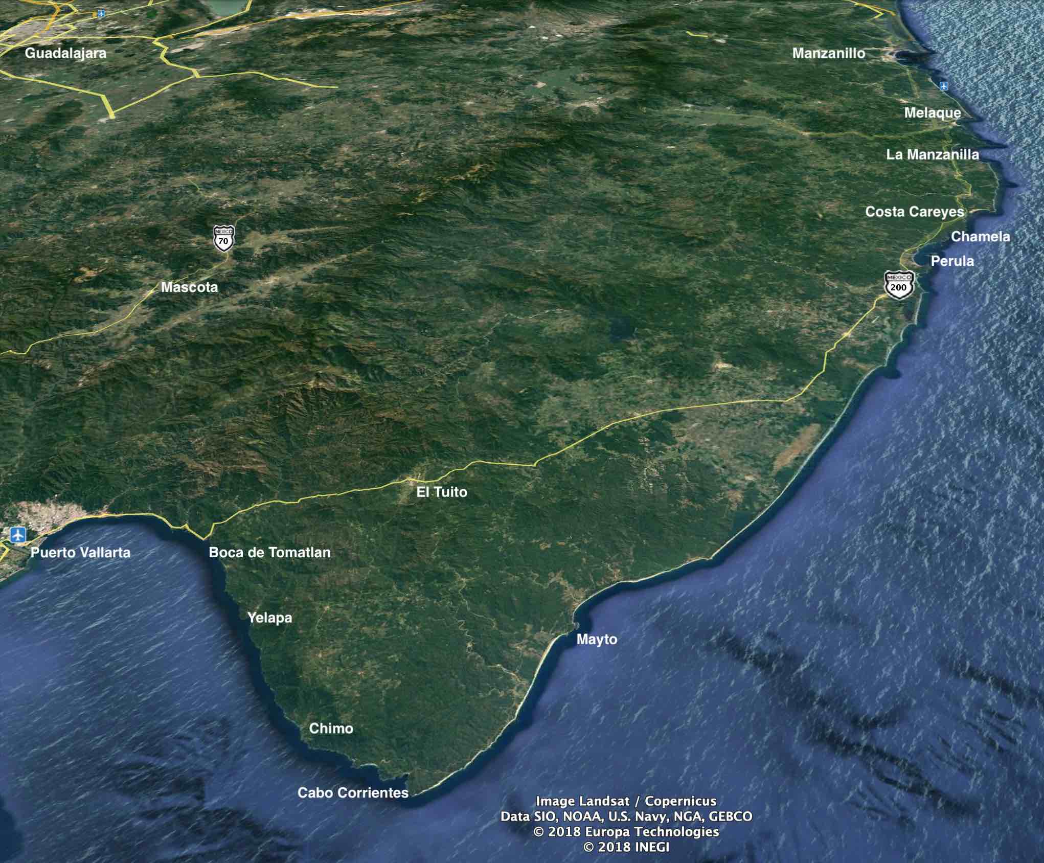
The main arterial road through this region is federal Highway 200 which runs mostly along of the coastline. Travelling south, from Sayulita it winds inland over the low mountain range to Bucerias and continues around the bay to Boca de Tomatlan where it then crosses over another mountain range towards Manzanillo.
In this region, many local areas are bisected by the highway leaving one side closer to the ocean and its beaches. Arguably preferable but more expensive real estate, several communities have a "golden zone" caused by the highway's disection. Bucerias, PV's Hotel Zone and Upper and Lower Conchas Chinas are a few examples.
Puerto Vallarta's municipal area is geographically large at 1300 square kilometers (500 square miles). It stretches from the Jalisco/Nayarit border south around the bay to Boca de Tomatlan. The total population of the bay area is about 375,000 with about 2/3 living in Puerto Vallarta. Similarly, 2/3 of real estate sales occur on the Puerto Vallarta side of the bay.

Three principle rivers flow into the bay from the mountains: Rio Ameca, Rio Pitillal and Rio Cuale.
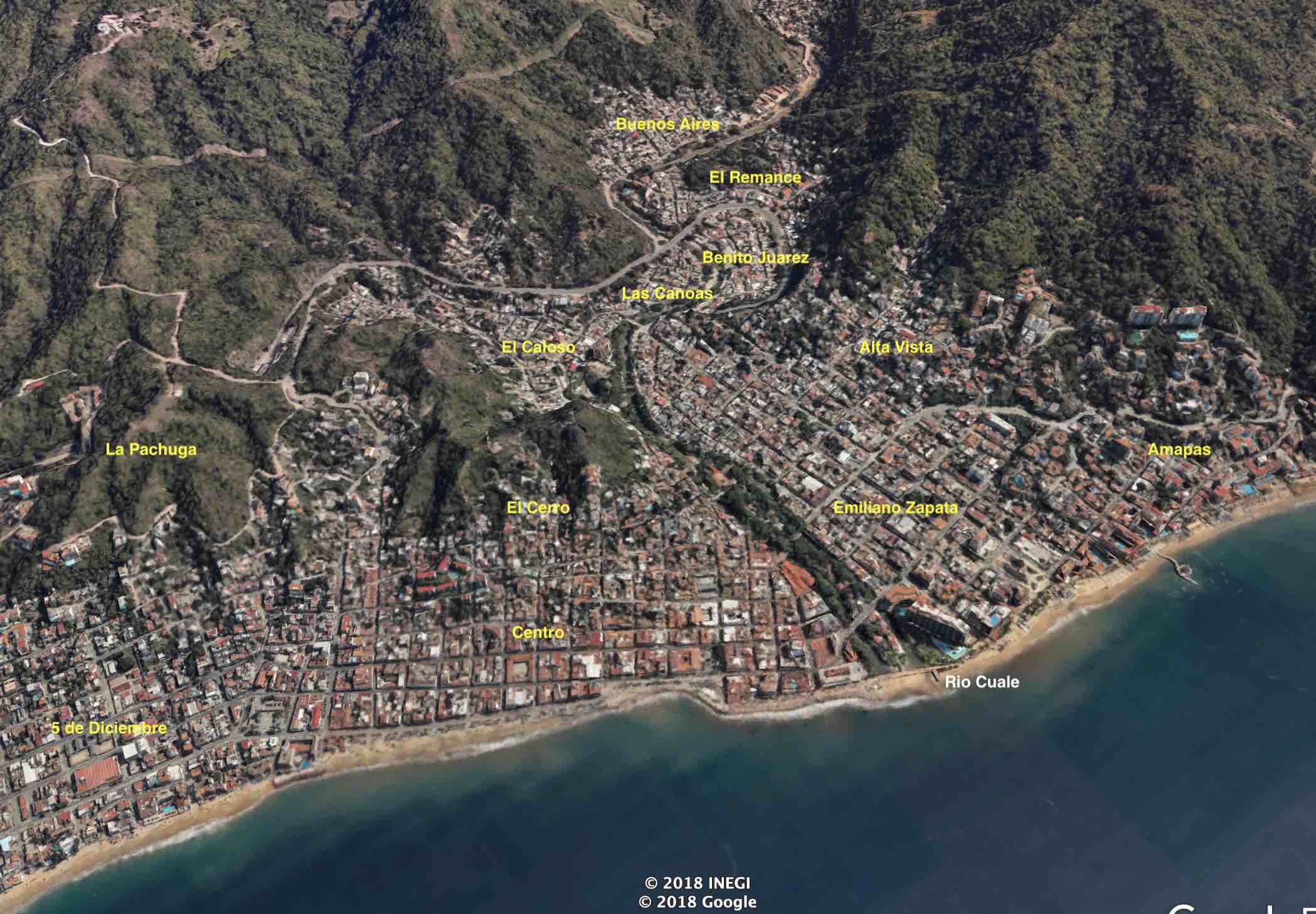
Downtown is centered around the banks of the Rio Cuale. This is where Puerto Vallarta was first established in the 1850s, then truly a sleepy fishing village known as Las Peñas. While the fertile Ameca valley has always been important to the region, the Cuale river was as far south as one could easily get and where the greatest protection from ocean storms was provided.
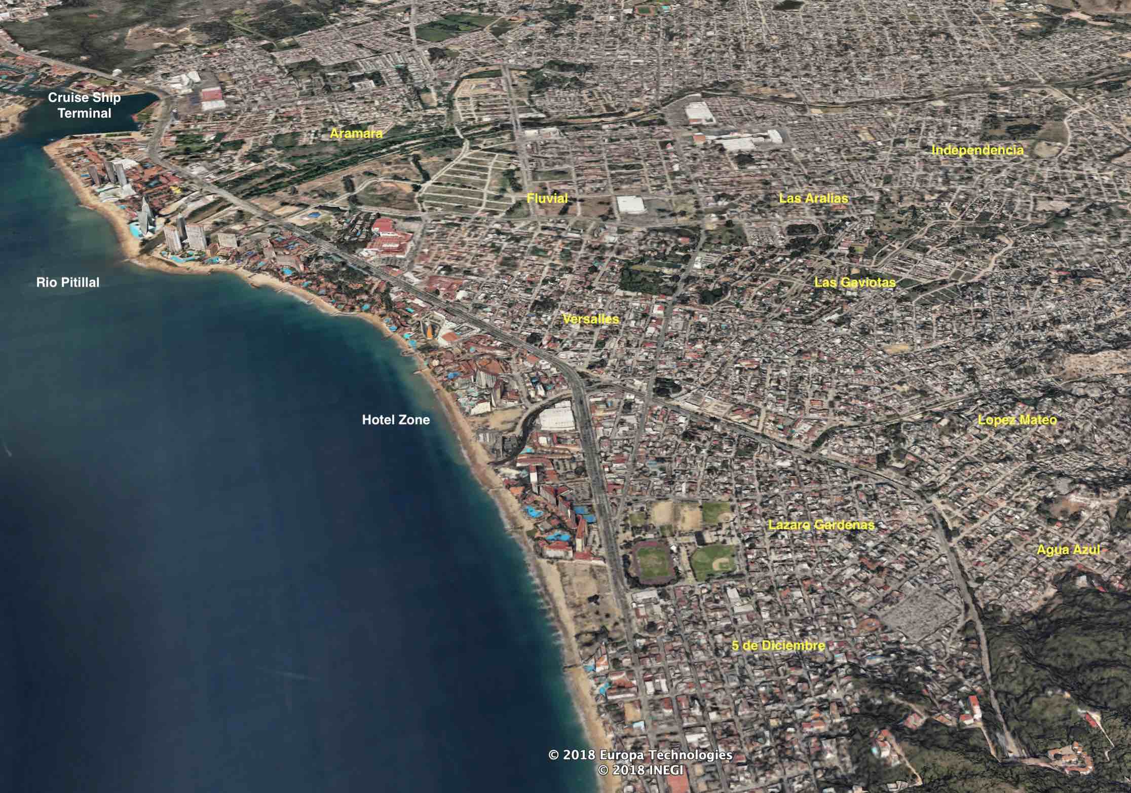
As can be seen in the accompanying image, between the airport and the Rio Pitillal is a large nature estuary. The city grew hugging the accompanying hillsides towards the open valley from the small plain where the town was established. Midtown is that area south of the estuary towards downtown. Northeast is that large area north and east of the Pitillal River stretching into the valley.
Originally settled on the banks of the Rio Cuale, downtown Puerto Vallarta straddles both sides of the river and some find it best defined in three distinct groupings: Downtown North, Downtown South and Downtown East. The accompanying image labels the various neighbourhoods or colonias that make up the downtown area.
Downtown North includes the site of the original town, colonia El Centro, where you'll find Puerto Vallarta's famous malecon (seaside esplanade) and the church of Our Lady of Guadalupe with its iconic crown. Above Col. Centro is El Cerro and to its north is Col. 5 de Diciembre.
Downtown South, often called South Side or Old Town, it includes colonias Emilana Zapata, Alta Vista and here Amapas. This is a very popular area for which there is a surge of condominium development. Much of this area is also referred to as Zona Romantica although that is more of a tourism expression than an officially deemed area.
Downtown East are those colonias on both sides of the river but back further from the coastline where real property values are generally cheaper than the ocean side of downtown.
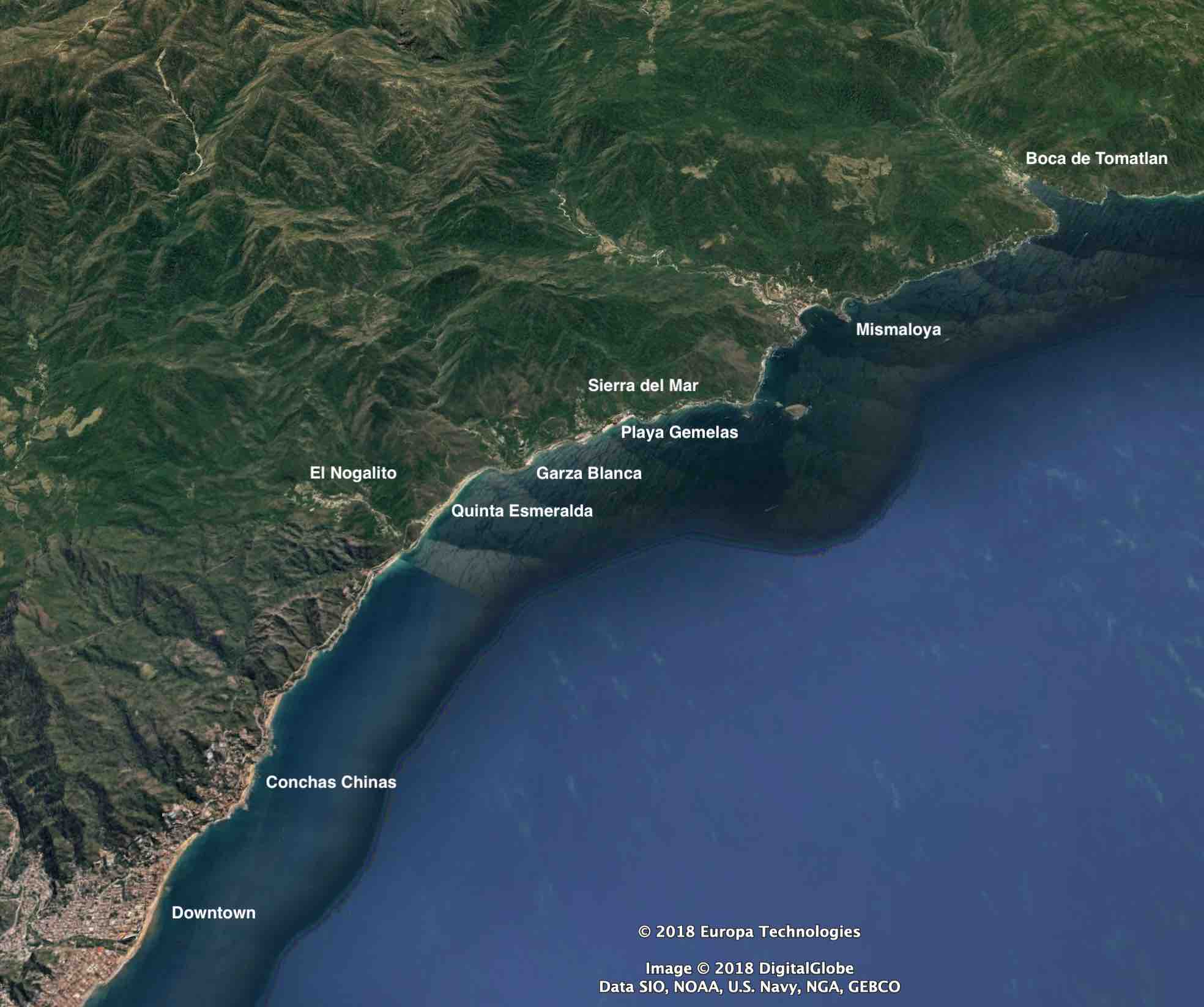
Along the narrow coastline to Boca de Tomatlan, Hwy 200 heads south from the city and at Boca it crosses over the low range mountains towards Manzanillo. Some of the communities found along what is called the South Shore are identified in the accompanying image.
Mismaloya is where Night of the Iguana was filmed. In those days Hwy 200 nor any road existed along the narrow coastline. Consequently, the film crew had to travel there each day from the Rio Cuale by small boats called pangas.
Nowadays, along Hwy 200 are a number of communities and developments to fit all tastes and budgets.
Immediately south of downtown is Conchas Chinas, often referred to as the Beverly Hills of Puerto Vallarta, one of the first built communities accessed by the new highway. As you drive south along the highway towards Mismaloya you'll see our infamous Los Arcos Marine Park. The Arches are an iconic symbol of Puerto Vallarta.
Central through town is a large swath of land between the estuary and downtown and southeast of the Pitillal River to the tunnel entrance of the Libramiento. For lack of any better name, I refer to this area as Midtown Vallarta. An area becoming popular to purchase real estate.
As Hwy 200 heads south past the estuary on the east side, the marina and cruise ship terminal to the west, the area opens up commercially with malls, hotels, condominiums and residential neighborhoods.
As you pass the cruise ship terminal, the strip of land between the highway and the beach is the Hotel Zone. Here hotels and condominiums vie for the beach space there is.
As you approach the Sheraton Hotel area, an optional route to bypass downtown comes available via the Libramiento. This circular route to the south side heads east and through a tunnel as it heads around the back side of downtown.
Off these two principle throroughfares are a variety of main avenues accessing communities of various ages, styles, layouts and prices, yet all share a common trait: All very central to the area with good transportation and services and with downtown nearby.
Popular colonias in this area include Fluvial, Las Aralias, Versalles, Las Gaviotas and Aramara.
This area is well serviced with malls, restaurants and movie theatres. Suburbia Mexican style with each colonia having its own unique mix of houses and condominiums.
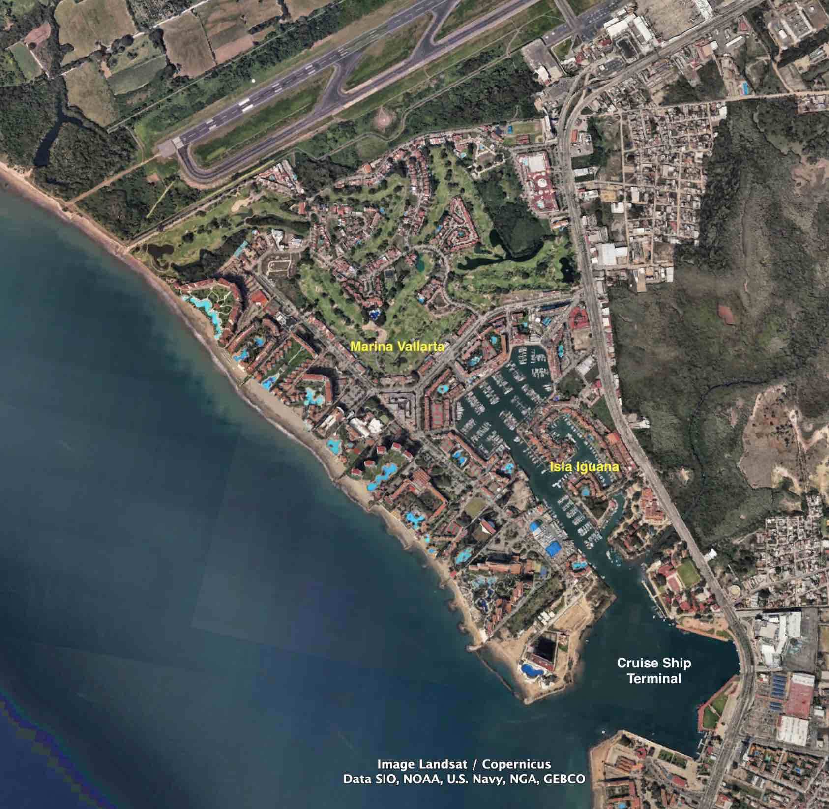
Marina Vallarta is a planned community built in the 1980s. Adjacent to the airport on reclaimed land, here you'll find a mixture of luxury hotels and a variety of condominium choices on the ocean or around the 354-slip marina. Additionally, there's an 18-hole public golf course with a variety of houses and townhomes built around it. The marina itself is accessible to the ocean through the cruise ship terminal waters.
Adjoining Marina Vallarta is Isla Iguana, a gated community of three separate condo associations: Plaza Iguana, Puerto Iguana and Punta Iguana. They are mostly 2 level townhouses including some with their own private boat slip and/or pool.
Both areas are well serviced with restaurants and shops by the marina promenade that connects them together.
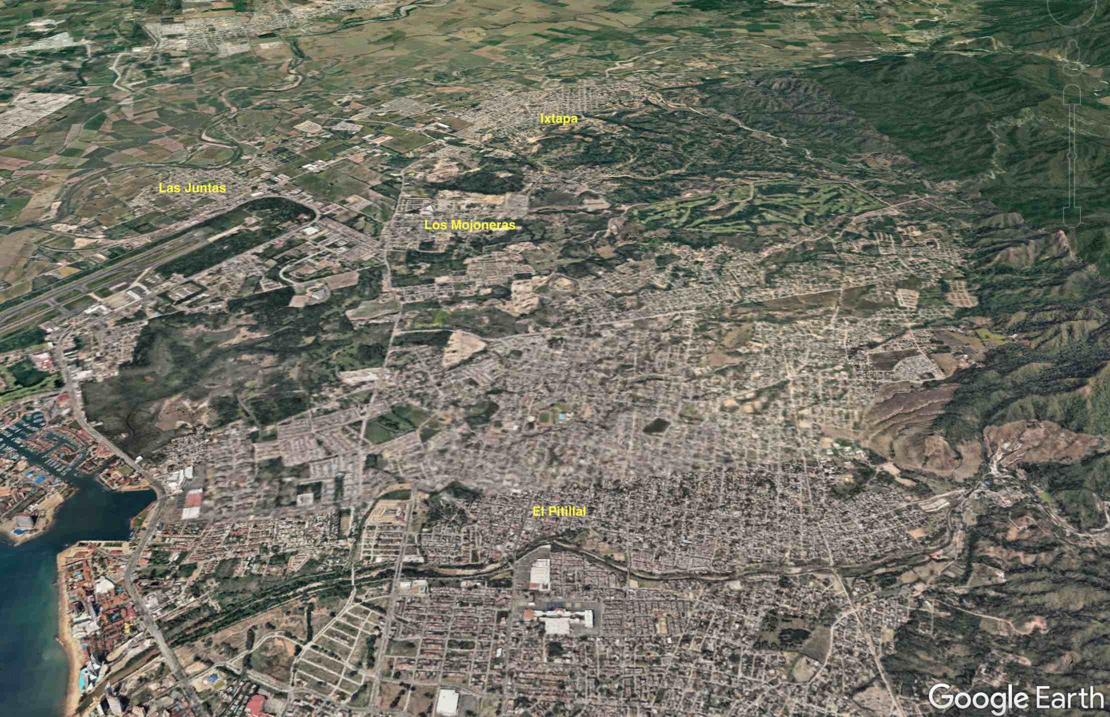
Northeast of the Pitillal river is where much growth is currently occuring to meet the needs of the local population. Of interest to some foreign buyers is the bustling town of Pitillal. Nowadays, it has been absorbed into the city but it was once a distant village with its own square and centro area. All around and northeast of Pitillal is quickly growing primarily as bedroom communities for the local workforce.
Near the airport is Los Mojoneras, Las Juntas on its other side and further inland is Ixtapa, an old farming community where real estate prices are more reasonable compared to more central locations.
There are two areas to point out in the accompanying image. The large dark green open space between the marina and Las Mojoneras is an estuary that will likely never be developed. The other green space situated on the hillsides east of Las Mojoneras is Vista Vallarta, an 18-hole Jack Nicklaus designed golf course which opened in 2001.
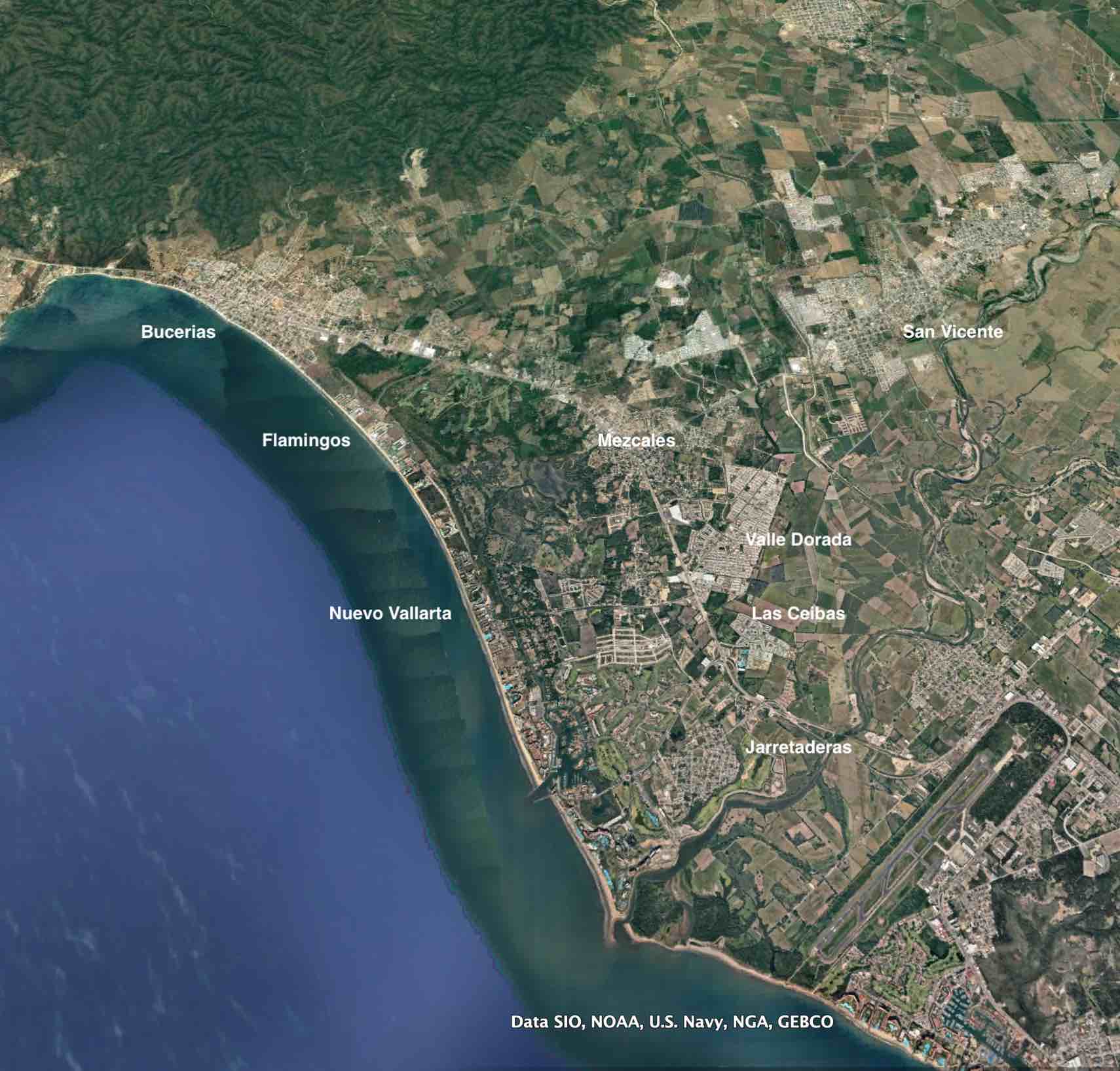
Nuevo Vallarta is a planned community tapping into the tourism market Puerto Vallarta developed over the years. The Ameca valley has always been important to the region and older communities have existed a long time serving the farmers and fishermen of the area including those identified in the accompanying image: Bucerias, Mezcales, San Vicente and Jarretaderas, all on or near Hwy 200 which transects the valley on its way south to Puerto Vallarta.
The Hwy 200 corridor between Bucerias and the airport was widened about 20 years ago including the installation of a new bridge across the Ameca River to improve the highway's traffic flow. Today, the entire stretch is filling in and becoming a well serviced suburban center along with new communities like Las Ceibas and Valle Dorado springing up that not only serve the needs of the local population but provide affordable choices to expats retiring.
Between Hwy 200 and the ocean is Nuevo Vallarta, a mixture of hotels, condominiums and houses along with two golf courses, a marina and a shopping mall. Flamingos to the north is considered part of Nuevo Vallarta but years ago, before there was a Nuevo Vallarta, Flamingos was known primarily for its golf course. Nuevo Vallarta has yet another golf course at the south end and both have housing around them.
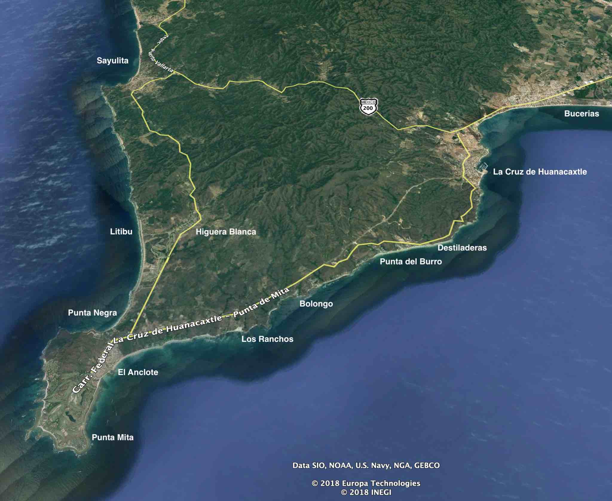
La Cruz de Huanacaxtle is just beyond Bucerias where Hwy 200 leaves the valley and heads north to Sayulita and other towns further up coast. After the highway passes through a narrow passage it opens again to a small plain where "La Cruz" is situated. An exit from the highway takes you along the northern coast of Banderas Bay to Punta Mita and the nearby communities of Litibu and Higuera Blanca.
The stretch of real estate between La Cruz and Punta Mita is referred to as the North Shore or Costa Banderas and features a variety of communities typically of luxurious properties and developments, some identified on the accompanying image.
Punta Mita is one large gated community of luxury homes where inside is the Four Seasons resort and golf course with its own private villas available for sale. Nearby to Punta Mita is El Anclote and Higuera Blanca where homes are cheaper and where some of the local workforce lives.
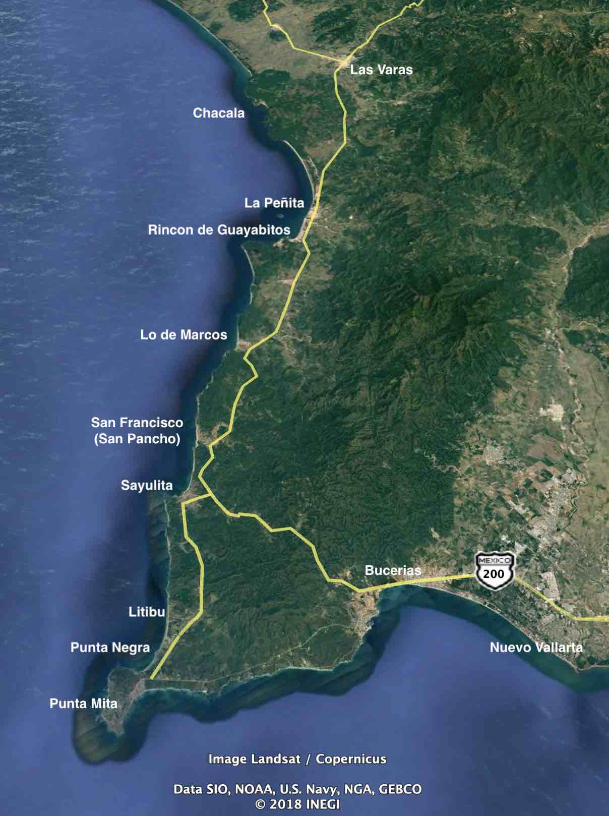
North of Punta Mita are a variety of seaside towns collectively known as Costa Nayarit. They vary in size and each have their own personality with the most popular being Sayulita, a community of about 5,000 that swells in the winter months with returning snowbirds. Hwy 200 continues north near the coastline up to Las Varas from where it then crosses over the mountains on its way to Tepic, the capital of Nayarit. A variety of towns and fishing villages exist along the coast including Lo de Marcos, San Pancho (San Francisco), La Piñeta, Rincon de Guayabitas, and others.
The mountains surrounding Puerto Vallarta are the Sierra Madres, and they're pretty special, too.
The Sierra Madres run the length of the country. Those hurricanes that do not veer from the coast but rather go east and make landfall quickly dissipate in their attempt to cross land. The mountains break the storms and release their tremendous rainwater onto the mountains that inevitably find its way back to the ocean.
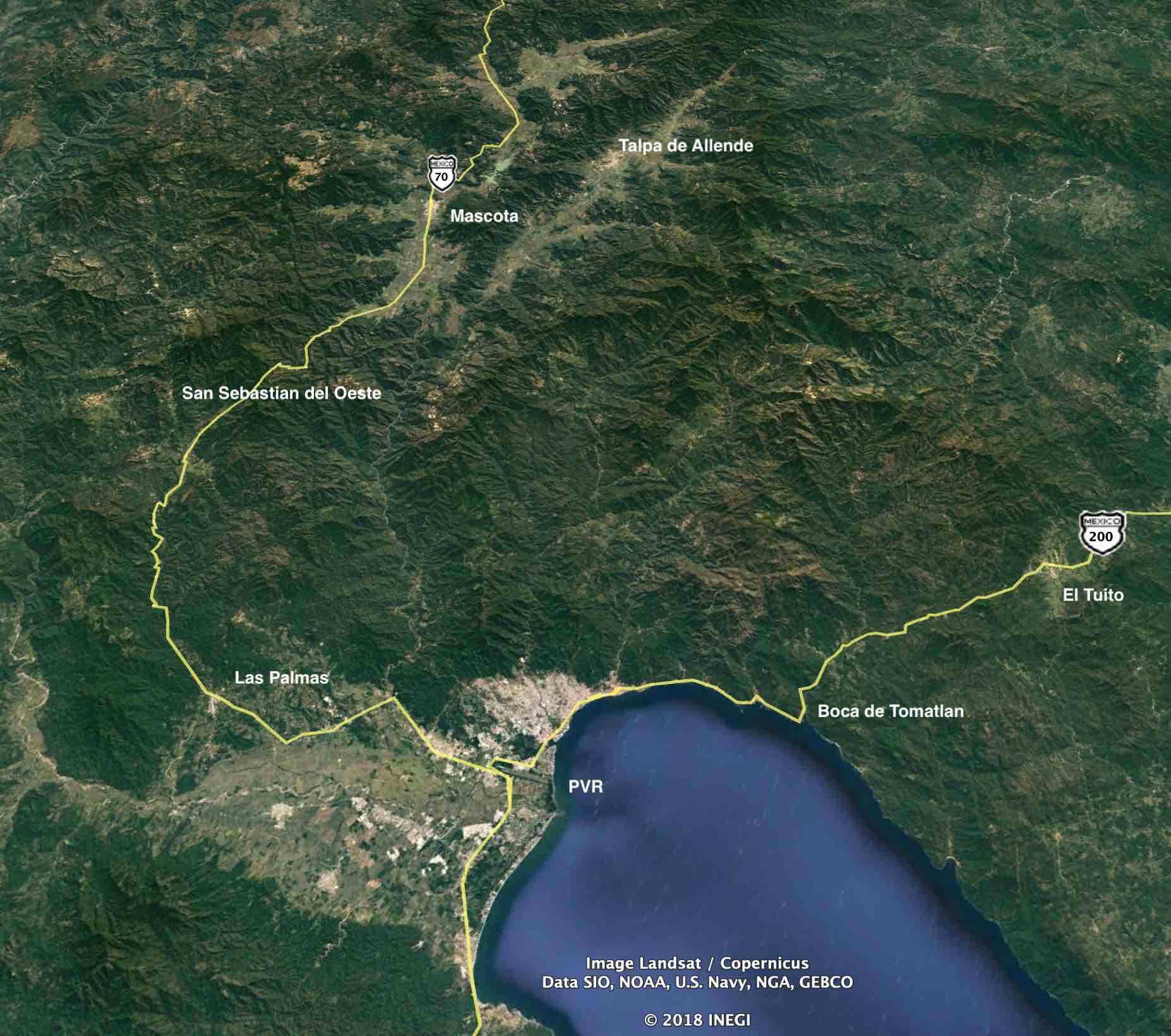
The mountains are special in other ways too. Within a couple of hours drive, you can leave your hammock on the beach in Puerto Vallarta on a hot muggy day and trade it for a much cooler and dryer climate several thousand feet above sea level. State Highway 506 exits Hwy 200 near the airport and heads west into the mountains. At Mascota it becomes federal Hwy 70, an optional route to Guadalajara, the state capital of Jalisco.
A popular village to visit and for some expats to buy and settle in is San Sebastian del Oeste, a mountain puebla of about a thousand people a mere couple hours east of Vallarta. This was once a thriving silver mining town in the 1800's that relied on the Ameca valley for its food and supplies and who were PV's original tourists, visiting during their time off from the mines.
Today, San Sebastian remains a quiant village with a smaller population than its heyday as a silver mining town. At about 1400 meters above sea level, about 4500 feet, it's noticeably cooler than Puerto Vallarta and a jacket or sweater is required in the evenings throughout the year.
This refreshing temparate air attracts some expats to consider a purchase there or in other similar mountain communities such as Mascota or Talpa de Allende that seemingly offer the best of both worlds. A temparate climate in which to live, but only a short distance to the hot tropics and ocean whenever desired.
Another option is El Tuito, an hour's drive south of Vallarta on Hwy 200. Tuito is not as high an elevation as the other choices but, at over 600 meters (about 2,000 feet), it still provides noticeable climatic relief from the dog days of summer. And you may need a jacket or sweater there too.
Looking south from Puerto Vallarta, Hwy 200 continues to Manzanillo in the next state of Colima. Along the coast between Puerto Vallarta and Manzanillo are a number of seaside communities, each again offering their own personalities and expat followers. This strip of real estate - Melaque, La Manzanilla, Costa Careyes, Chamela, Mayto - is referred to as Costa Alegre.